CAL FIRE and the California Fire Risk Map: What It Is, What It Means, and Why It Matters for Your Home
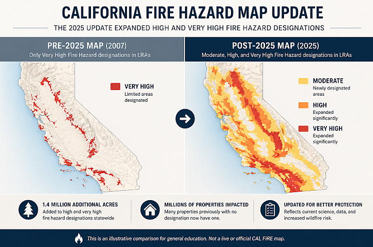
If you own a home in California, there's a good chance the rules that apply to your property changed in 2025. In February and March of that year, CAL FIRE released the most significant update to its Fire Hazard Severity Zone maps since 2007, adding 1.4 million acres to high and very high fire hazard designations statewide. Many properties that had no fire zone designation now have one. Many that were Moderate are now High or Very High.
Most homeowners don't know this has happened. And the ones who do often don't fully understand what it means for them practically: what they're required to do, what they're no longer allowed to do, and what happens if they ignore it.
This article explains what CAL FIRE is, what the fire risk maps show, how to check your property, and what a fire zone designation actually requires of you as a homeowner.
What Is CAL FIRE?
CAL FIRE is the California Department of Forestry and Fire Protection. It's the state agency responsible for fire protection across more than 31 million acres of privately owned wildland in California, along with direct emergency services in 36 of California's 58 counties through contracts with local governments.
CAL FIRE's responsibilities go beyond fighting fires. The agency is also responsible for wildfire prevention, forest health, fire safety building standards, and the classification of fire hazard across California's landscape. That classification work is what produces the Fire Hazard Severity Zone maps most homeowners are trying to understand.
TheCAL FIRE website is the primary source for current incident information, fire hazard maps, home hardening guidance, and approved building materials for fire-prone areas.
What Is a Fire Hazard Severity Zone?
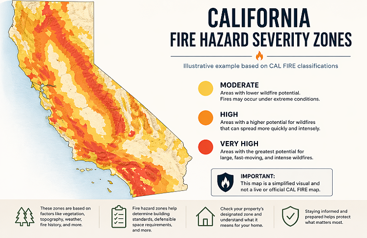
A Fire Hazard Severity Zone (FHSZ) is a geographic classification that describes the level of fire risk associated with a particular area. CAL FIRE assigns zones based on six primary factors:
Vegetation is the primary fuel for wildfire, and different vegetation types carry different risk levels. Chaparral, dry grassland, and dense brush create higher hazard than maintained landscape.
Topography shapes how fire moves. Fires travel faster and burn more intensely up steep slopes. Canyon and drainage configurations can accelerate fire behavior significantly.
Climate and weather patterns factor in temperature, humidity, and wind exposure. Areas prone to Santa Ana conditions in Southern California and Diablo winds in Northern California carry elevated ratings.
Crown fire potential reflects the likelihood of fire reaching the tops of trees and tall brush, which creates more intense and faster-spreading fires.
Ember production and travel accounts for the documented ability of burning embers to travel up to a mile ahead of a fire front and ignite structures far from the main fire line.
Fire history incorporates documented fire occurrence in an area over several decades.
Based on these factors, CAL FIRE classifies land into three FHSZ tiers: Moderate, High, and Very High. There is also a special designation for State Responsibility Areas called Extreme, though this applies primarily to remote wildland locations rather than residential communities.
State Responsibility Area vs. Local Responsibility Area
One of the more confusing aspects of the CAL FIRE map is the distinction between State Responsibility Areas and Local Responsibility Areas.
A State Responsibility Area (SRA) is land where the state government has primary financial responsibility for wildfire prevention and suppression. This includes most privately owned wildlands in California outside of incorporated cities. CAL FIRE directly provides fire protection services in SRAs.
A Local Responsibility Area (LRA) includes incorporated cities and counties where local government, not the state, has primary fire protection responsibility. Local fire departments and CAL FIRE contract counties handle fire response in LRAs.
Both SRAs and LRAs can contain Fire Hazard Severity Zones. The regulatory requirements that apply to properties in these zones, including building standards, defensible space rules, and disclosure obligations, apply in both. The key difference is which agency administers enforcement and inspections.
The 2025 map update specifically focused on LRA maps, which hadn't been comprehensively updated since 2007. The SRA maps had been updated in 2024. Together, the combined 2024 to 2025 update cycle represents the most current picture of fire hazard across California's landscape.
The 2025 California Fire Map Update: What Changed
The 2025 LRA Fire Hazard Severity Zone maps were released in four phases by the Office of the State Fire Marshal:
Phase 1: February 10, 2025
Phase 2: February 24, 2025
Phase 3: March 10, 2025
Phase 4: March 24, 2025 (covering Southern California, including Los Angeles County)
This was the first comprehensive LRA update in 18 years. The previous LRA maps, released in 2007, only included Very High fire hazard designations. The 2025 maps added Moderate and High designations for the first time in LRAs, significantly expanding the number of properties with formal fire zone classifications.
The scale of the change is significant. The revised maps added 1.4 million additional acres to high and very high fire hazard severity zones statewide. In Los Angeles, San Diego, Ventura, Marin, and other counties, the number of affected parcels increased substantially. Areas adjacent to open space that had no prior designation, particularly in suburban communities, are now newly classified.
The update incorporates more current data on fuels, fire weather patterns, terrain analysis, and fire history that simply wasn't available when the previous maps were produced. It also reflects the documented increase in wildfire frequency and severity across California over the intervening 18 years.
How to Check Your Property on the California Fire Risk Map
The fastest way to find your property's Fire Hazard Severity Zone designation is through the CAL FIRE FHSZ Viewer maintained by the Office of the State Fire Marshal. Enter your address and the tool will show your zone designation, if any, under both the SRA and LRA classifications.
A few things to keep in mind when checking the map:
If your parcel spans more than one FHSZ, the highest designation applies to the entire parcel. A property that is 90 percent Moderate and 10 percent High is treated as High for regulatory purposes.
Local jurisdictions can increase but not decrease the state's recommended zone. Under California Government Code Section 51179, a city or county cannot reduce a fire hazard designation below what the state has recommended, but they can add properties or increase designations beyond the state baseline. This means the state map shows the minimum designation for your property, not necessarily the final one once your local jurisdiction adopts its ordinance.
Some cities and counties were still in the process of formally adopting the 2025 maps during 2025, so enforcement timelines vary by jurisdiction. Check with your local fire department or building department for the adoption status in your specific city or county.
What a Fire Hazard Severity Zone Designation Means for Homeowners
A fire zone designation isn't just a label. It triggers a specific set of regulatory requirements that apply to your property.
Defensible Space Requirements
Properties in High and Very High Fire Hazard Severity Zones are required by law to maintain defensible space around structures. This includes clearing flammable vegetation within 100 feet of the structure (or to the property line if it's closer), with specific treatment standards at different distances. Zone Zero requirements, covering the 0 to 5 feet immediately around the structure, apply specifically to non-combustible materials, including fencing.
Building Code Requirements
New construction and significant remodels on properties in High and Very High FHSZs must comply with Chapter 7A of the California Building Code, which mandates wildfire-resistant construction standards for roofing, siding, windows, vents, and decks. Properties in Very High zones face the strictest standards.
The 2025 California Wildland-Urban Interface Code (Title 24, Part 7), effective January 1, 2026, consolidated and clarified these requirements into a single enforceable code. For fencing specifically, this code governs material requirements for fence installations in WUI-designated areas.
Disclosure Obligations
Under AB 38 (California Civil Code Section 1102.19), sellers of residential property in High and Very High FHSZs are required to provide buyers with documentation that the property is in compliance with defensible space requirements. This includes a Defensible Space Inspection conducted by the local fire authority. Non-compliant properties either need to be remediated before close of escrow or the buyer must agree in writing to obtain compliance within one year.
Insurance Implications
The California Department of Insurance has emphasized that FHSZ designations themselves do not directly set insurance rates or determine coverage availability. However, your fire zone designation is one input among many that insurers use to assess risk, and properties in Very High FHSZs are subject to greater scrutiny from underwriters.
Home hardening measures, including Zone Zero compliant fencing, are increasingly factored into coverage decisions. Documented compliance can support your position with insurers, particularly in markets where coverage availability has declined.
What the Map Means for Your Fence Specifically
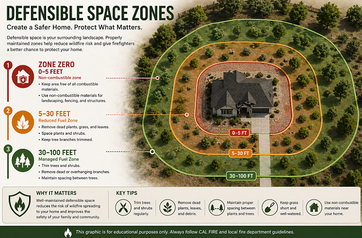
One of the most direct and immediate consequences of a High or Very High FHSZ designation is the requirement to address combustible materials in Zone Zero, the 0 to 5 foot perimeter around your home's structure.
A wood or vinyl fence running within 5 feet of your exterior walls is a Zone Zero violation in a designated fire hazard severity zone. This applies regardless of when the fence was installed, and there are no grandfathering provisions once Zone Zero requirements take effect. Most homeowners have until 2029 to retrofit existing combustible fencing under California's three-year compliance window.
Non-combustible fencing that satisfies Zone Zero requirements must meet ignition-resistant material standards. For residential fencing, the primary option with both the material qualifications and the specific CAL FIRE listing is hot-dipped galvanized steel. MWF Solutions products carry CAL FIRE Listing #8170 under Ignition-Resistant Materials, along with an ASTM Class A Fire Rating (Zero Flame Spread).
If you've checked the map and found that your property is newly designated as High or Very High, the fence question is worth addressing proactively. Defensible space inspections under AB 38 and local enforcement programs will specifically look at Zone Zero materials, and wood or vinyl fencing is the most commonly cited deficiency.
Checking the CAL FIRE Active Fire Map
Separate from the FHSZ designation map, CAL FIRE also maintains a real-time active incidents map showing current and recent wildfires across California. This is the resource to check during Red Flag Warning periods, when monitoring fire activity near your area, or when tracking evacuation orders and warnings.
The active fire map is updated frequently and shows current fire perimeters, evacuation orders, evacuation warnings, and the status of ongoing responses. It also links to the CAL FIRE home hardening resources and approved building materials list.
During active fire seasons, the map is one of the most-used resources in the state. Bookmarking it and understanding how to read the different alert levels (evacuation warning versus evacuation order versus normal) is worth doing before you need it.
What to Do If Your Property Is in a Fire Zone
If your property is in a High or Very High Fire Hazard Severity Zone, here's a practical starting point:
Confirm your designation at the CAL FIRE FHSZ Viewer. If you're in an LRA, also check with your local jurisdiction to confirm whether your city or county has adopted the 2025 maps and whether any local additions apply.
Evaluate Zone Zero. Walk the perimeter of your home and identify any combustible fence, deck material, or vegetation within 5 feet of your exterior walls, eaves, or deck attachments.
Understand your AB 38 obligations if you're planning to sell. A Defensible Space Inspection will be required, and a combustible fence in Zone Zero will be flagged as a deficiency.
Review your insurance situation. Contact your insurer to understand how your FHSZ designation factors into your coverage and whether documented home hardening measures can support your policy terms.
Address fencing in Zone Zero with a CAL FIRE listed non-combustible product before the compliance deadline. MWF Solutions carries California inventory and can typically complete delivery and installation within two weeks of order.
Check your fire zone and explore compliant fencing options at MWF Solutions
Frequently Asked Questions
What is CAL FIRE?
CAL FIRE is the California Department of Forestry and Fire Protection, the state agency responsible for fire protection, wildfire prevention, and forest stewardship across California's privately owned wildlands. CAL FIRE also maintains the Fire Hazard Severity Zone maps that determine regulatory requirements for properties across the state.
What is the CAL FIRE fire hazard map?
The CAL FIRE Fire Hazard Severity Zone (FHSZ) map classifies California land into Moderate, High, and Very High fire hazard zones based on factors including vegetation, topography, weather patterns, ember production, and fire history. Properties in designated zones are subject to defensible space requirements, building code standards, and AB 38 disclosure obligations. The map can be searched by address at the CAL FIRE FHSZ Viewer at egis.fire.ca.gov/FHSZ.
What changed in the 2025 California fire map update?
The 2025 LRA map update was the first comprehensive revision of Local Responsibility Area maps since 2007. Released in four phases between February and March 2025, the update added 1.4 million acres to high and very high fire hazard severity zones statewide. It also introduced Moderate and High zone classifications in LRAs for the first time. Many properties in suburban communities adjacent to open space received new or elevated fire zone designations as a result.
How do I find my property on the California fire risk map?
Go to the CAL FIRE FHSZ Viewer at egis.fire.ca.gov/FHSZ and enter your property address. The tool will show your current fire hazard severity zone designation, if any. If your parcel spans multiple zones, the highest designation applies to the entire parcel. Also check with your local city or county to confirm whether additional local designations apply beyond the state recommendation.
Does a CAL FIRE designation affect my home insurance?
Not directly, according to the California Department of Insurance, which has noted that FHSZ maps do not set insurance rates or determine coverage availability. However, your fire zone designation is one factor among many in how insurers assess property risk. Documented home hardening measures, including Zone Zero compliant fencing, can support your position with insurers and may factor into underwriting decisions in high-risk areas.
What does a Very High Fire Hazard Severity Zone mean for my fence?
Properties in High and Very High FHSZs are required to maintain Zone Zero compliance, meaning materials within 0 to 5 feet of your home's structure must be non-combustible or certified ignition-resistant. Wood and vinyl fencing within Zone Zero does not comply. Hot-dipped galvanized steel with CAL FIRE listing, such as MWF Solutions products under Listing #8170, satisfies Zone Zero requirements. Most homeowners have until 2029 to retrofit existing fencing under California's three-year compliance window.
What is the difference between the CAL FIRE hazard map and the active fire map?
The Fire Hazard Severity Zone map is a permanent classification of land-based fire risk. It shows where regulatory requirements apply and doesn't change with active fire conditions. The CAL FIRE active incidents map is a real-time tool showing current wildfires, evacuation orders, and emergency alerts. Both are maintained at the CAL FIRE website at fire.ca.gov.